
Make a donation
Gear up for your next adventure:
As an Amazon Associate, this site earns from qualifying purchases at no extra cost to you.
Stevensville topographic map
Click on the map to display elevation.
Make a donation
Gear up for your next adventure:
As an Amazon Associate, this site earns from qualifying purchases at no extra cost to you.
About this map
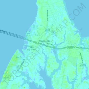
Name: Stevensville topographic map, elevation, terrain.
Location: Stevensville, Queen Anne's County, Maryland, United States (38.94386 -76.35551 39.01179 -76.28974)
Average elevation: 2 m
Minimum elevation: -2 m
Maximum elevation: 16 m
Make a donation
Gear up for your next adventure:
As an Amazon Associate, this site earns from qualifying purchases at no extra cost to you.
Other topographic maps
Click on a map to view its topography, its elevation and its terrain.
Wye Mills
United States > Maryland > Queen Anne's County
Wye Mills is an unincorporated community in Talbot County, Maryland, United States, located at an altitude of 20 feet (6.1 m). Wye Mills is located at the intersection of Maryland routes 404 and 662, just south of the Queen Anne's County border.
Average elevation: 15 m