
Carballo topographic map
Interactive map
Click on the map to display elevation.
About this map
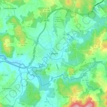
Name: Carballo topographic map, elevation, terrain.
Location: Carballo, Bergantiños, Ла-Корунья, Галисия, 15102, Испания (43.17341 -8.72913 43.25341 -8.64913)
Average elevation: 144 m
Minimum elevation: 88 m
Maximum elevation: 319 m
Other topographic maps
Click on a map to view its topography, its elevation and its terrain.
A Brea
Испания > Галисия > Bergantiños > Carballo
A Brea, Carballo, Bergantiños, Ла-Корунья, Галисия, 15100, Испания
Average elevation: 133 m
Ponteceso
Испания > Галисия > Bergantiños
Ponteceso, Bergantiños, Ла-Корунья, Галисия, 15115, Испания
Average elevation: 53 m