Geolocate

10 topographic map

Click on the map to display elevation.

About this map

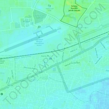
Name: 10 topographic map, elevation, terrain.

Location: 10, Patna, Patna Rural, Patna District, Bihar, 800001, India (25.58026 85.08546 25.59517 85.11477)

Average elevation: 54 m

Minimum elevation: 50 m

Maximum elevation: 61 m

Other topographic maps

Click on a map to view its topography, its elevation and its terrain.

IAS COLONY PARK

India > Bihar > Patna Rural > Patna

Average elevation: 54 m

Gear up for your next adventure:

🧊Insulated Water Bottle - Keeps drinks cold in summer and prevents freezing in winter
Backpacking Tent - Lightweight tent for long-distance hiking trips
🧴Bear Spray Holster - Quick-access carry for essential Canadian wilderness safety
🧥Fleece Jacket - Warm and lightweight jacket for layering
🚲Heavy Duty Bike Lock - Secure your bike at the trailhead or during stops

As an Amazon Associate, this site earns from qualifying purchases at no extra cost to you.