
Make a donation
Gear up for your next adventure:
As an Amazon Associate, this site earns from qualifying purchases at no extra cost to you.
Fuhai topographic map
Click on the map to display elevation.
Make a donation
Gear up for your next adventure:
As an Amazon Associate, this site earns from qualifying purchases at no extra cost to you.
Fuhai
The Altai Mountains traverses Fuhai County, and the two main rivers in the county are the Ulungu Lake and the Irtysh River. Ulungu Lake is located in Fuhai County. The county's elevation ranges from 386 to 3,332 m (1,266 to 10,932 ft), with an average elevation of about 500 m (1,640 ft).
Make a donation
Gear up for your next adventure:
As an Amazon Associate, this site earns from qualifying purchases at no extra cost to you.
About this map
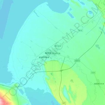
Name: Fuhai topographic map, elevation, terrain.
Location: Fuhai, Fuhai County, Altay Prefecture, Xinjiang, 836400, China (46.95149 87.32375 47.27149 87.64375)
Average elevation: 504 m
Minimum elevation: 479 m
Maximum elevation: 715 m
Make a donation
Gear up for your next adventure:
As an Amazon Associate, this site earns from qualifying purchases at no extra cost to you.