Geolocate

Shivalik topographic map

Click on the map to display elevation.

About this map
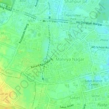
Name: Shivalik topographic map, elevation, terrain.

Location: Shivalik, Hauz Khas Tehsil, South Delhi, Delhi, India (28.52914 77.20513 28.54094 77.21305)

Average elevation: 230 m

Minimum elevation: 220 m

Maximum elevation: 243 m

Other topographic maps

Click on a map to view its topography, its elevation and its terrain.
Chattarpur

India > Delhi

Average elevation: 261 m

Tajpur Pahadi

India > Delhi

Average elevation: 209 m

Rangpuri

India > Delhi

Average elevation: 244 m

Sunder Nursery

India > Delhi

Average elevation: 209 m

Sanjay Lake Park

India > Delhi

Average elevation: 205 m

District Park Sarita Vihar

India > Delhi

Average elevation: 211 m

Coronation Park

India > Delhi

Average elevation: 209 m

Aya Nagar

India > Delhi

Average elevation: 272 m

Coronation Park

India > Delhi

Average elevation: 209 m

Sunder Nursery

India > Delhi

Average elevation: 209 m

Aya Nagar

India > Delhi

Average elevation: 272 m

Gear up for your next adventure:

🥾Hiking Gaiters - Protect legs and shoes from mud, snow, and debris
🧥Waterproof Hiking Jacket - Protect yourself from rain and wind while hiking
🧤Rechargeable Heated Gloves - Extreme warmth for Canadian winter expeditions
🥾Trail Hiking Socks - Comfortable socks to prevent blisters and fatigue
🦶Hiking Shoe Insoles - Added support for high arches and long days on feet

As an Amazon Associate, this site earns from qualifying purchases at no extra cost to you.