Geolocate

Pipas topographic map

Click on the map to display elevation.

About this map

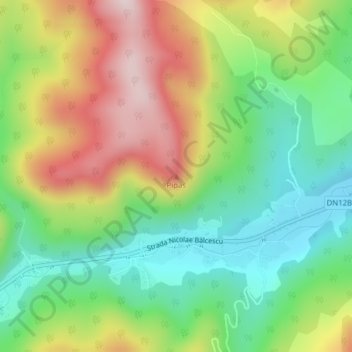
Name: Pipas topographic map, elevation, terrain.

Location: Pipas, Slănic-Moldova, Bacău, 605500, Romania (46.22825 26.47389 46.22835 26.47399)

Average elevation: 570 m

Minimum elevation: 400 m

Maximum elevation: 813 m

Gear up for your next adventure:

🧴Sunscreen SPF - Broad-spectrum sunscreen for outdoor activities
🛰️Satellite Messenger - Emergency communication for areas with no cell service
🥾Waterproof Trail Shoes - Shoes designed to handle wet terrain
🥾Mountaineering Boots - Supportive boots for climbing and high-altitude hiking
💧Hydration Pack - Hands-free hydration system for long hikes

As an Amazon Associate, this site earns from qualifying purchases at no extra cost to you.