
Make a donation
Gear up for your next adventure:
As an Amazon Associate, this site earns from qualifying purchases at no extra cost to you.
Kamiak Butte topographic map
Click on the map to display elevation.
Make a donation
Gear up for your next adventure:
As an Amazon Associate, this site earns from qualifying purchases at no extra cost to you.
About this map
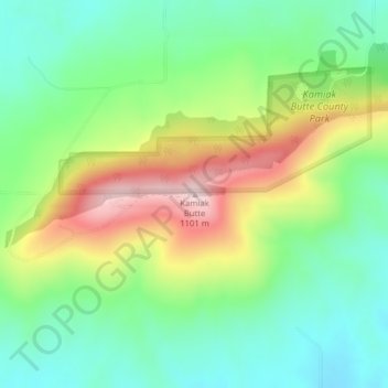
Name: Kamiak Butte topographic map, elevation, terrain.
Location: Kamiak Butte, Whitman County, Washington, United States (46.86230 -117.16730 46.86240 -117.16720)
Average elevation: 883 m
Minimum elevation: 759 m
Maximum elevation: 1,098 m
Make a donation
Gear up for your next adventure:
As an Amazon Associate, this site earns from qualifying purchases at no extra cost to you.
Other topographic maps
Click on a map to view its topography, its elevation and its terrain.
Tekoa
United States > Washington > Whitman County
Tekoa was incorporated in 1889 with just under 300 people at the base of Tekoa Mountain (elevation 2,490 feet), on the extreme eastern end of the Palouse, and to the west of the Benewah Range of Idaho. In 1908 the railroad trestle above the town was built. By 1910 the population had grown to 1,694. Over the…
Average elevation: 792 m
Make a donation
Gear up for your next adventure:
As an Amazon Associate, this site earns from qualifying purchases at no extra cost to you.
Colfax
United States > Washington > Whitman County
Colfax is located in southeastern Washington at 46°53′3″N 117°21′49″W / 46.88417°N 117.36361°W / 46.88417; -117.36361 (46.884033, -117.363668), at an elevation of 1,962 feet (598 m). The nearest cities are Spokane, Pullman, Moscow, and Lewiston/Clarkston. The area is geologically…
Average elevation: 685 m