
Make a donation
Gear up for your next adventure:
As an Amazon Associate, this site earns from qualifying purchases at no extra cost to you.
Col de la Perche topographic map
Click on the map to display elevation.
Make a donation
Gear up for your next adventure:
As an Amazon Associate, this site earns from qualifying purchases at no extra cost to you.
Col de la Perche
Historisch gezien maakte het graafschap Cerdanya deel uit van de provincie Roussillon, het noordelijkste deel van Catalonië en later de Kroon van Aragón. Sinds het Verdrag van de Pyreneeën in 1659 behoort het noordelijke deel van Cerdanya, tezamen met de Conflent en de Roussillon tot Frankrijk en ligt de pasweg in Frankrijk. Vanwege de geringe hoogte van de pas vormt Cerdanya al eeuwen een overgangsgebied tussen Frankrijk en Spanje.
Make a donation
Gear up for your next adventure:
As an Amazon Associate, this site earns from qualifying purchases at no extra cost to you.
About this map
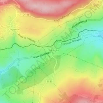
Name: Col de la Perche topographic map, elevation, terrain.
Average elevation: 1,608 m
Minimum elevation: 1,502 m
Maximum elevation: 1,717 m
Make a donation
Gear up for your next adventure:
As an Amazon Associate, this site earns from qualifying purchases at no extra cost to you.