
Make a donation
Gear up for your next adventure:
As an Amazon Associate, this site earns from qualifying purchases at no extra cost to you.
Dreißigacker topographic map
Click on the map to display elevation.
Make a donation
Gear up for your next adventure:
As an Amazon Associate, this site earns from qualifying purchases at no extra cost to you.
Dreißigacker
Dreißigacker liegt am östlichen Rand einer Hochebene im Werratal rund einen Kilometer westlich der Kernstadt an der Landesstraße 2621 und östlich vom Stadtteil Herpf auf einer Höhe von 430 Meter über NN (Ortskern).
Make a donation
Gear up for your next adventure:
As an Amazon Associate, this site earns from qualifying purchases at no extra cost to you.
About this map
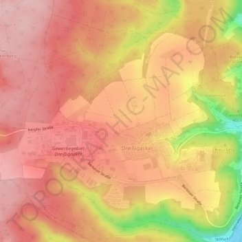
Name: Dreißigacker topographic map, elevation, terrain.
Average elevation: 429 m
Minimum elevation: 291 m
Maximum elevation: 488 m
Make a donation
Gear up for your next adventure:
As an Amazon Associate, this site earns from qualifying purchases at no extra cost to you.
Other topographic maps
Click on a map to view its topography, its elevation and its terrain.
Träbes
Deutschland > Thüringen > Landkreis Schmalkalden-Meiningen > Meiningen
Average elevation: 529 m
Hakenberg
Deutschland > Thüringen > Landkreis Schmalkalden-Meiningen > Meiningen
Average elevation: 401 m
Bielstein
Deutschland > Thüringen > Landkreis Schmalkalden-Meiningen > Meiningen
Average elevation: 361 m