
Make a donation
Gear up for your next adventure:
As an Amazon Associate, this site earns from qualifying purchases at no extra cost to you.
Guadalupe Mountains National Park topographic map
Click on the map to display elevation.
Make a donation
Gear up for your next adventure:
As an Amazon Associate, this site earns from qualifying purchases at no extra cost to you.
Guadalupe Mountains National Park
The Guadalupe Mountains reach their highest point at Guadalupe Peak, the highest point in Texas, with an elevation of 8,751 feet (2,667 m). The range lies southeast of the Sacramento Mountains and east of the Brokeoff Mountains. The mountain range extends north-northwest and northeast from Guadalupe Peak in Texas into New Mexico. The northeastern extension ends about 10 miles (16 km) southwest of Carlsbad, near Carlsbad Caverns National Park; the southwest tip ends with El Capitan about 90 miles (140 km) east of El Paso. The mountains rise more than 3,000 feet (910 m) above the arid floor of the Chihuahuan Desert. The Guadalupe Mountains are surrounded by the South Plains to the east and north, Delaware Mountains to the south, and Sacramento Mountains to the west.
Make a donation
Gear up for your next adventure:
As an Amazon Associate, this site earns from qualifying purchases at no extra cost to you.
About this map
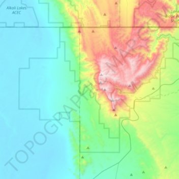
Name: Guadalupe Mountains National Park topographic map, elevation, terrain.
Average elevation: 1,484 m
Minimum elevation: 1,100 m
Maximum elevation: 2,650 m
Make a donation
Gear up for your next adventure:
As an Amazon Associate, this site earns from qualifying purchases at no extra cost to you.
Other topographic maps
Click on a map to view its topography, its elevation and its terrain.
Guadalupe Peak
United States > Texas > Culberson County
Guadalupe Peak, also known as Signal Peak, is the highest natural point in Texas, with an elevation of 8,751 feet (2,667 m) above sea level. It is located in Guadalupe Mountains National Park, and is part of the Guadalupe Mountains range in southeastern New Mexico and West Texas. The mountain is about 90 miles…
Average elevation: 2,150 m