
Bendung topographic map
Interactive map
Click on the map to display elevation.
About this map
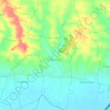
Name: Bendung topographic map, elevation, terrain.
Location: Bendung, Mojokerto, East Java, Indonesia (-7.41350 112.41291 -7.37236 112.45251)
Average elevation: 44 m
Minimum elevation: 17 m
Maximum elevation: 93 m
Other topographic maps
Click on a map to view its topography, its elevation and its terrain.
Tawangsari
Indonesia > East Java > Mojokerto
Tawangsari, Trowulan, Mojokerto, East Java, Jawa, Indonesia
Average elevation: 31 m