Geolocate

Phantom Terrace topographic map

Click on the map to display elevation.

About this map

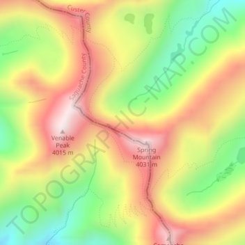
Name: Phantom Terrace topographic map, elevation, terrain.

Location: Phantom Terrace, Custer County, Colorado, United States (38.05551 -105.62145 38.05561 -105.62135)

Average elevation: 3,727 m

Minimum elevation: 3,391 m

Maximum elevation: 4,047 m

Other topographic maps

Click on a map to view its topography, its elevation and its terrain.

Westcliffe

United States > Colorado > Custer County

Average elevation: 2,404 m

Silver Cliff

United States > Colorado > Custer County

Average elevation: 2,455 m

Gear up for your next adventure:

🧥Packable Rain Jacket - Breathable waterproof layer for unpredictable weather
🧊Portable Cooler - Keep food and drinks cold during outdoor adventures
🧦Outdoor Socks - Durable socks designed for hiking and outdoor sports
🛶Canoe Life Vest - Safety vest for water sports
🥾Durable Hiking Shoes - Long-lasting shoes for frequent hiking

As an Amazon Associate, this site earns from qualifying purchases at no extra cost to you.