
Make a donation
Gear up for your next adventure:
As an Amazon Associate, this site earns from qualifying purchases at no extra cost to you.
Wolterdingen topographic map
Click on the map to display elevation.
Make a donation
Gear up for your next adventure:
As an Amazon Associate, this site earns from qualifying purchases at no extra cost to you.
About this map
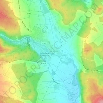
Name: Wolterdingen topographic map, elevation, terrain.
Average elevation: 746 m
Minimum elevation: 699 m
Maximum elevation: 823 m
Make a donation
Gear up for your next adventure:
As an Amazon Associate, this site earns from qualifying purchases at no extra cost to you.
Other topographic maps
Click on a map to view its topography, its elevation and its terrain.
Aasen
Deutschland > Baden-Württemberg > Schwarzwald-Baar-Kreis > Donaueschingen
Average elevation: 712 m
Grüningen
Deutschland > Baden-Württemberg > Schwarzwald-Baar-Kreis > Donaueschingen
Average elevation: 732 m
Wolterdingen
Deutschland > Baden-Württemberg > Schwarzwald-Baar-Kreis > Donaueschingen
Average elevation: 756 m
Hubertshofen
Deutschland > Baden-Württemberg > Schwarzwald-Baar-Kreis > Donaueschingen
Average elevation: 799 m
Make a donation
Gear up for your next adventure:
As an Amazon Associate, this site earns from qualifying purchases at no extra cost to you.
78166
Deutschland > Baden-Württemberg > Schwarzwald-Baar-Kreis > Donaueschingen > Pfohren
Average elevation: 750 m
78166
Deutschland > Baden-Württemberg > Schwarzwald-Baar-Kreis > Donaueschingen > Pfohren
Average elevation: 744 m