Geolocate

Aguadas topographic map

Click on the map to display elevation.

About this map

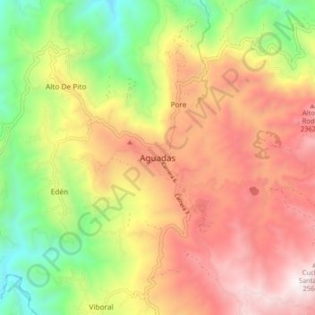
Name: Aguadas topographic map, elevation, terrain.

Location: Aguadas, Norte, Caldas, Colombia (5.57311 -75.49759 5.65311 -75.41759)

Average elevation: 1,859 m

Minimum elevation: 1,020 m

Maximum elevation: 2,670 m

Gear up for your next adventure:

🔥Emergency Fire Starter - Reliable ignition source for all weather conditions
👟Sport Hiking Sandals - Breathable footwear for water crossings and camp rest
🧴Insect Repellent - Protect yourself from bugs during outdoor adventures
🚲Bike Repair Kit - Essential tools for on-trail mechanical issues
💧Reusable Water Bottle - Durable water bottles for hydration on trails

As an Amazon Associate, this site earns from qualifying purchases at no extra cost to you.