Geolocate

Hillside topographic map

Click on the map to display elevation.

About this map

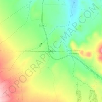
Name: Hillside topographic map, elevation, terrain.

Location: Hillside, Fremont County, Colorado, 81232, United States (38.24528 -105.63167 38.28528 -105.59167)

Average elevation: 2,309 m

Minimum elevation: 2,208 m

Maximum elevation: 2,446 m

Other topographic maps

Click on a map to view its topography, its elevation and its terrain.

Coal Creek

United States > Colorado > Fremont County

Average elevation: 1,671 m

Penrose

United States > Colorado > Fremont County

Average elevation: 1,629 m

Rockvale

United States > Colorado > Fremont County

Average elevation: 1,700 m

Brookside

United States > Colorado > Fremont County

Average elevation: 1,650 m

Gear up for your next adventure:

🧴Bear Spray Holster - Quick-access carry for essential Canadian wilderness safety
💡LED Headlamp - Hands-free illumination for night hiking and camping
🧦Outdoor Socks - Durable socks designed for hiking and outdoor sports
🧊Portable Cooler - Keep food and drinks cold during outdoor adventures
💡LED Camping Lantern - Illuminate your campsite with long-lasting lanterns

As an Amazon Associate, this site earns from qualifying purchases at no extra cost to you.