
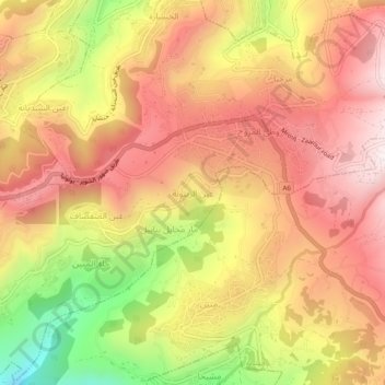
Ain Zaitoune topographic map
Interactive map
Click on the map to display elevation.
About this map
Name: Ain Zaitoune topographic map, elevation, terrain.
Average elevation: 1,087 m
Minimum elevation: 627 m
Maximum elevation: 1,388 m
Other topographic maps
Click on a map to view its topography, its elevation and its terrain.
Abey
Liban > Gouvernorat du Mont Liban
Abey, District d'Aley, Gouvernorat du Mont Liban, Liban
Average elevation: 577 m
Qarnayel
Liban > Gouvernorat du Mont Liban
Qarnayel, District de Baabda, Gouvernorat du Mont Liban, Liban
Average elevation: 1,068 m
Deir El Qamar
Liban > Gouvernorat du Mont Liban > Deir El Qamar
Deir El Qamar, District du Chouf, Gouvernorat du Mont Liban, 1503, Liban
Average elevation: 754 m
Burj Hammoud
Liban > Gouvernorat du Mont Liban > Bourj Hammoud > Burj Hammoud
Burj Hammoud, District de Metn, Gouvernorat du Mont Liban, 1203, Liban
Average elevation: 19 m
Khaldeh
Liban > Gouvernorat du Mont Liban > Khaldeh
Khaldeh, District d'Aley, Gouvernorat du Mont Liban, 1500, Liban
Average elevation: 149 m
Brih
Liban > Gouvernorat du Mont Liban > Brih
Brih, District du Chouf, Gouvernorat du Mont Liban, Liban
Average elevation: 966 m
Ain Zhalta
Liban > Gouvernorat du Mont Liban
Ain Zhalta, District d'Aley, Gouvernorat du Mont Liban, Liban
Average elevation: 1,124 m
Beiteddine
Liban > Gouvernorat du Mont Liban
Beiteddine, District du Chouf, Gouvernorat du Mont Liban, 1503, Liban
Average elevation: 861 m