
Thank you for supporting this site ❤️
Make a donation
Make a donation
Gear up for your next adventure:
As an Amazon Associate, this site earns from qualifying purchases at no extra cost to you.
Garber topographic map
Click on the map to display elevation.
Thank you for supporting this site ❤️
Make a donation
Make a donation
Gear up for your next adventure:
As an Amazon Associate, this site earns from qualifying purchases at no extra cost to you.
About this map
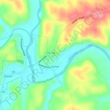
Name: Garber topographic map, elevation, terrain.
Location: Garber, Clayton County, Iowa, United States (42.73984 -91.26985 42.74994 -91.25284)
Average elevation: 231 m
Minimum elevation: 195 m
Maximum elevation: 289 m
Thank you for supporting this site ❤️
Make a donation
Make a donation
Gear up for your next adventure:
As an Amazon Associate, this site earns from qualifying purchases at no extra cost to you.
Other topographic maps
Click on a map to view its topography, its elevation and its terrain.
Driftless Area National Wildlife Refuge - Fern Ridge Unit
United States > Iowa > Clayton County
Average elevation: 269 m