
Make a donation
Gear up for your next adventure:
As an Amazon Associate, this site earns from qualifying purchases at no extra cost to you.
Lindetal topographic map
Click on the map to display elevation.
Make a donation
Gear up for your next adventure:
As an Amazon Associate, this site earns from qualifying purchases at no extra cost to you.
Lindetal
Lindetal liegt etwa 13 Kilometer südöstlich von Neubrandenburg und vier Kilometer östlich vom Amtssitz Burg Stargard. Die Gemeinde liegt an einem Endmoränenzug, dessen Höhen teilweise über 100 m ü. NN reichen. Namensgebend für die Gemeinde ist die durch den Westen der Gemarkung fließende Linde.
Make a donation
Gear up for your next adventure:
As an Amazon Associate, this site earns from qualifying purchases at no extra cost to you.
About this map
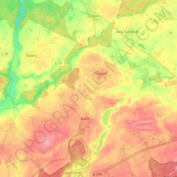
Name: Lindetal topographic map, elevation, terrain.
Average elevation: 94 m
Minimum elevation: 45 m
Maximum elevation: 128 m
Make a donation
Gear up for your next adventure:
As an Amazon Associate, this site earns from qualifying purchases at no extra cost to you.
Other topographic maps
Click on a map to view its topography, its elevation and its terrain.
Strehlow
Deutschland > Mecklenburg-Vorpommern > Mecklenburgische Seenplatte > Hohenbrünzow
Average elevation: 41 m
Törpin
Deutschland > Mecklenburg-Vorpommern > Mecklenburgische Seenplatte > Sarow
Average elevation: 54 m
Loickenzin
Deutschland > Mecklenburg-Vorpommern > Mecklenburgische Seenplatte > Altentreptow > Loickenzin
Average elevation: 43 m
Make a donation
Gear up for your next adventure:
As an Amazon Associate, this site earns from qualifying purchases at no extra cost to you.
Lindow
Deutschland > Mecklenburg-Vorpommern > Mecklenburgische Seenplatte > Lindow
Average elevation: 73 m
Bresewitz
Deutschland > Mecklenburg-Vorpommern > Mecklenburgische Seenplatte > Friedland
Average elevation: 23 m