Geolocate

Ciambar topographic map

Click on the map to display elevation.

About this map

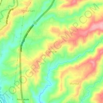
Name: Ciambar topographic map, elevation, terrain.

Location: Ciambar, Sukabumi, West Java, Java, Indonesia (-6.86457 106.75329 -6.78457 106.83329)

Average elevation: 480 m

Minimum elevation: 369 m

Maximum elevation: 670 m

Other topographic maps

Click on a map to view its topography, its elevation and its terrain.

Cibodas

Indonesia > West Java > Sukabumi > Cimenteng

Average elevation: 260 m

Cisolok

Indonesia > West Java > Sukabumi

Average elevation: 62 m

Cikahuripan

Indonesia > West Java > Sukabumi

Average elevation: 110 m

Gear up for your next adventure:

🧊Portable Cooler - Keep food and drinks cold during outdoor adventures
🗺️Topographic Maps - Detailed maps to explore trails, mountains, and wilderness areas
🥾Lightweight Hiking Shoes - Comfortable shoes for day hikes
🔋Emergency Crank Radio - Weather alerts and power without needing batteries
🧭Orienteering Kit - Tools for map reading and navigation in the wild

As an Amazon Associate, this site earns from qualifying purchases at no extra cost to you.