
Ramagundam topographic map
Click on the map to display elevation.
Ramagundam
Ramagundam is located at 18°45′50″N 79°28′30″E / 18.7638°N 79.4750°E / 18.7638; 79.4750. It has an average elevation of 179 meters (590 feet). It is about 225 kilometres (140 mi) northeast of the state capital, Hyderabad, 65 km from Karimnagar, 0 km from Ramagundam district headquarters and 0.1 km from Godavarikhani.
About this map
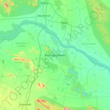
Name: Ramagundam topographic map, elevation, terrain.
Average elevation: 174 m
Minimum elevation: 90 m
Maximum elevation: 514 m
Other topographic maps
Click on a map to view its topography, its elevation and its terrain.
Godavarikhani Bus-Stand
India > Telangana > Ramagundam mandal > Godavari Khani
Average elevation: 148 m