
Make a donation
Gear up for your next adventure:
As an Amazon Associate, this site earns from qualifying purchases at no extra cost to you.
East Nottingham Township topographic map
Click on the map to display elevation.
Make a donation
Gear up for your next adventure:
As an Amazon Associate, this site earns from qualifying purchases at no extra cost to you.
About this map
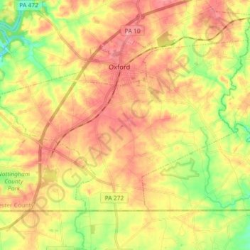
Name: East Nottingham Township topographic map, elevation, terrain.
Average elevation: 137 m
Minimum elevation: 74 m
Maximum elevation: 190 m
Make a donation
Gear up for your next adventure:
As an Amazon Associate, this site earns from qualifying purchases at no extra cost to you.
Other topographic maps
Click on a map to view its topography, its elevation and its terrain.
Chester Springs
United States > Pennsylvania > Chester County > West Pikeland Township
Average elevation: 112 m
Chesterbrook
United States > Pennsylvania > Chester County > Tredyffrin Township
Average elevation: 81 m
Make a donation
Gear up for your next adventure:
As an Amazon Associate, this site earns from qualifying purchases at no extra cost to you.
West Goshen
United States > Pennsylvania > Chester County > West Goshen Township
Average elevation: 127 m
Chatwood
United States > Pennsylvania > Chester County > West Goshen Township
Average elevation: 129 m
Exton
United States > Pennsylvania > Chester County > West Whiteland Township
Average elevation: 125 m
Make a donation
Gear up for your next adventure:
As an Amazon Associate, this site earns from qualifying purchases at no extra cost to you.
Kimberton
United States > Pennsylvania > Chester County > East Pikeland Township
Kimberton is located at 40°07′50″N 75°34′20″W / 40.13056°N 75.57222°W / 40.13056; -75.57222 (40.130N, -75.572W). The elevation is 207 feet.
Average elevation: 75 m
Kirkwood Preserve
United States > Pennsylvania > Chester County > Willistown Township
Average elevation: 117 m
West Pikeland
United States > Pennsylvania > Chester County > West Pikeland Township
Average elevation: 122 m
Make a donation
Gear up for your next adventure:
As an Amazon Associate, this site earns from qualifying purchases at no extra cost to you.
Strickersville
United States > Pennsylvania > Chester County > London Britain Township
Average elevation: 94 m
Romansville
United States > Pennsylvania > Chester County > West Bradford Township
Average elevation: 123 m
Doe Run
United States > Pennsylvania > Chester County > West Marlborough Township
Average elevation: 118 m
Wilson Farm Park
United States > Pennsylvania > Chester County > Tredyffrin Township > Chesterbrook
Average elevation: 68 m
Make a donation
Gear up for your next adventure:
As an Amazon Associate, this site earns from qualifying purchases at no extra cost to you.
Glenloch
United States > Pennsylvania > Chester County > West Whiteland Township
Average elevation: 139 m
Morstein
United States > Pennsylvania > Chester County > West Whiteland Township
Average elevation: 151 m
Cochranville
United States > Pennsylvania > Chester County > West Fallowfield Township
Average elevation: 170 m
Make a donation
Gear up for your next adventure:
As an Amazon Associate, this site earns from qualifying purchases at no extra cost to you.
Kenilworth
United States > Pennsylvania > Chester County > North Coventry Township
Average elevation: 61 m
Make a donation
Gear up for your next adventure:
As an Amazon Associate, this site earns from qualifying purchases at no extra cost to you.
Pughtown
United States > Pennsylvania > Chester County > South Coventry Township
Average elevation: 122 m
South Pottstown
United States > Pennsylvania > Chester County > North Coventry Township
Average elevation: 61 m
Make a donation
Gear up for your next adventure:
As an Amazon Associate, this site earns from qualifying purchases at no extra cost to you.
Toughkenamon
United States > Pennsylvania > Chester County > New Garden Township
Average elevation: 115 m
Unionville
United States > Pennsylvania > Chester County > East Marlborough Township
Average elevation: 134 m
Make a donation
Gear up for your next adventure:
As an Amazon Associate, this site earns from qualifying purchases at no extra cost to you.
Black Horse
United States > Pennsylvania > Chester County > West Sadsbury Township
Average elevation: 211 m
Brandamore
United States > Pennsylvania > Chester County > West Brandywine Township
Average elevation: 191 m
Cedarville
United States > Pennsylvania > Chester County > North Coventry Township
Average elevation: 82 m
Chatham
United States > Pennsylvania > Chester County > London Grove Township
Average elevation: 133 m
Make a donation
Gear up for your next adventure:
As an Amazon Associate, this site earns from qualifying purchases at no extra cost to you.
Chesterville
United States > Pennsylvania > Chester County > Franklin Township
Average elevation: 103 m
Coventryville
United States > Pennsylvania > Chester County > South Coventry Township
Average elevation: 137 m
Make a donation
Gear up for your next adventure:
As an Amazon Associate, this site earns from qualifying purchases at no extra cost to you.
Darlington Corners
United States > Pennsylvania > Chester County > Thornbury Township > Westtown
Average elevation: 111 m
Dorlan
United States > Pennsylvania > Chester County > East Brandywine Township
Average elevation: 132 m
Ercildoun
United States > Pennsylvania > Chester County > East Fallowfield Township
Average elevation: 149 m
Faggs Manor
United States > Pennsylvania > Chester County > Londonderry Township
Average elevation: 177 m
Make a donation
Gear up for your next adventure:
As an Amazon Associate, this site earns from qualifying purchases at no extra cost to you.
Goshenville
United States > Pennsylvania > Chester County > East Goshen Township
Average elevation: 132 m
Hallman
United States > Pennsylvania > Chester County > East Pikeland Township
Average elevation: 94 m
Harmonyville
United States > Pennsylvania > Chester County > Warwick Township
Average elevation: 175 m
Hayesville
United States > Pennsylvania > Chester County > Lower Oxford Township
Average elevation: 163 m
Make a donation
Gear up for your next adventure:
As an Amazon Associate, this site earns from qualifying purchases at no extra cost to you.
Hephzibah
United States > Pennsylvania > Chester County > East Fallowfield Township
Average elevation: 132 m
Hiestand
United States > Pennsylvania > Chester County > East Vincent Township
Average elevation: 89 m
Homeville
United States > Pennsylvania > Chester County > Upper Oxford Township
Average elevation: 138 m
Hopewell
United States > Pennsylvania > Chester County > East Nottingham Township
Average elevation: 136 m
Make a donation
Gear up for your next adventure:
As an Amazon Associate, this site earns from qualifying purchases at no extra cost to you.
Humphreyville
United States > Pennsylvania > Chester County > East Fallowfield Township
Average elevation: 168 m
Icedale
United States > Pennsylvania > Chester County > West Brandywine Township
Average elevation: 198 m
Ironsides
United States > Pennsylvania > Chester County > Schuylkill Township
Ironsides is a populated place located within the township of Schuylkill in Chester County, Pennsylvania, United States. It has an estimated elevation of 118 feet (36 m) above sea level.
Average elevation: 61 m
Isabella
United States > Pennsylvania > Chester County > West Nantmeal Township
Average elevation: 200 m
Make a donation
Gear up for your next adventure:
As an Amazon Associate, this site earns from qualifying purchases at no extra cost to you.
Kemblesville
United States > Pennsylvania > Chester County > Franklin Township
Average elevation: 104 m
Make a donation
Gear up for your next adventure:
As an Amazon Associate, this site earns from qualifying purchases at no extra cost to you.
Lenape
United States > Pennsylvania > Chester County > Pocopson Township > Pocopson
Average elevation: 79 m
London Grove
United States > Pennsylvania > Chester County > West Marlborough Township
Average elevation: 131 m
Lower Hopewell
United States > Pennsylvania > Chester County > Lower Oxford Township
Average elevation: 128 m
Make a donation
Gear up for your next adventure:
As an Amazon Associate, this site earns from qualifying purchases at no extra cost to you.
Ludwigs Corner
United States > Pennsylvania > Chester County > West Vincent Township
Average elevation: 182 m
Lyndell
United States > Pennsylvania > Chester County > East Brandywine Township
Average elevation: 137 m
Mortonville
United States > Pennsylvania > Chester County > East Fallowfield Township
Average elevation: 122 m
Make a donation
Gear up for your next adventure:
As an Amazon Associate, this site earns from qualifying purchases at no extra cost to you.
Nantmeal Village
United States > Pennsylvania > Chester County > East Nantmeal Township
Average elevation: 171 m
Parker Ford
United States > Pennsylvania > Chester County > East Coventry Township
Average elevation: 60 m
Russellville
United States > Pennsylvania > Chester County > Upper Oxford Township
Average elevation: 176 m
Saint Peters
United States > Pennsylvania > Chester County > Warwick Township
Average elevation: 157 m
Make a donation
Gear up for your next adventure:
As an Amazon Associate, this site earns from qualifying purchases at no extra cost to you.
Siousca
United States > Pennsylvania > Chester County > West Brandywine Township
Average elevation: 155 m
Springdell
United States > Pennsylvania > Chester County > West Marlborough Township
Average elevation: 132 m
Steelville
United States > Pennsylvania > Chester County > West Fallowfield Township
Average elevation: 164 m
Sugartown
United States > Pennsylvania > Chester County > Willistown Township
Average elevation: 137 m
Make a donation
Gear up for your next adventure:
As an Amazon Associate, this site earns from qualifying purchases at no extra cost to you.
Whitford
United States > Pennsylvania > Chester County > West Whiteland Township
Average elevation: 122 m
Willowdale
United States > Pennsylvania > Chester County > East Marlborough Township
Average elevation: 120 m
Make a donation
Gear up for your next adventure:
As an Amazon Associate, this site earns from qualifying purchases at no extra cost to you.
flood plane
United States > Pennsylvania > Chester County > Uwchlan Township > Lionville
Average elevation: 149 m
Pottstown Landing
United States > Pennsylvania > Chester County > North Coventry Township
Average elevation: 66 m
Whiteland Crest
United States > Pennsylvania > Chester County > West Whiteland Township > Exton
Average elevation: 127 m
Whitehorse
United States > Pennsylvania > Chester County > Willistown Township
Average elevation: 117 m
Make a donation
Gear up for your next adventure:
As an Amazon Associate, this site earns from qualifying purchases at no extra cost to you.
Milford Mills
United States > Pennsylvania > Chester County > Upper Uwchlan Township
Average elevation: 126 m
Marshallton
United States > Pennsylvania > Chester County > West Bradford Township
Average elevation: 98 m
Make a donation
Gear up for your next adventure:
As an Amazon Associate, this site earns from qualifying purchases at no extra cost to you.
Grove
United States > Pennsylvania > Chester County > West Whiteland Township > Grove
Average elevation: 128 m
Gallagherville
United States > Pennsylvania > Chester County > Gallagherville
Average elevation: 115 m
Slonaker
United States > Pennsylvania > Chester County > East Vincent Township > Slonaker
Average elevation: 98 m
Make a donation
Gear up for your next adventure:
As an Amazon Associate, this site earns from qualifying purchases at no extra cost to you.
Sadsburyville
United States > Pennsylvania > Chester County > Sadsbury Township
Average elevation: 191 m
Hershey Mill
United States > Pennsylvania > Chester County > East Goshen Township > Hershey Mill
Average elevation: 150 m
Bucktown
United States > Pennsylvania > Chester County > South Coventry Township
Average elevation: 115 m
Make a donation
Gear up for your next adventure:
As an Amazon Associate, this site earns from qualifying purchases at no extra cost to you.
Charlestown
United States > Pennsylvania > Chester County > Charlestown Township > Charlestown
Average elevation: 101 m
Birchrunville
United States > Pennsylvania > Chester County > West Vincent Township
Average elevation: 141 m