Geolocate

Seynod topographic map

Click on the map to display elevation.

About this map

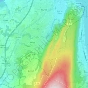
Name: Seynod topographic map, elevation, terrain.

Location: Seynod, Annecy, Upper Savoy, Auvergne-Rhône-Alpes, Metropolitan France, 74600, France (45.82800 6.04841 45.89548 6.11865)

Average elevation: 651 m

Minimum elevation: 416 m

Maximum elevation: 1,334 m

Other topographic maps

Click on a map to view its topography, its elevation and its terrain.

Grand Jean

France > Auvergne-Rhône-Alpes > Upper Savoy > Annecy > Vieugy

Average elevation: 646 m

Bois Jettaz

France > Auvergne-Rhône-Alpes > Upper Savoy > Annecy

Average elevation: 593 m

Gear up for your next adventure:

🧥Thermal Layer - Insulating layer for cold outdoor conditions
🧰Survival Kit - Essential gear for emergencies in the wilderness
📷Outdoor Action Camera - Capture high-elevation views and rugged adventures
🥾Light Trekking Boots - Supportive boots for multi-day treks
🥾Light Hiking Boots - Lightweight and comfortable boots for day hikes

As an Amazon Associate, this site earns from qualifying purchases at no extra cost to you.