Geolocate

Grafton topographic map

Click on the map to display elevation.

About this map

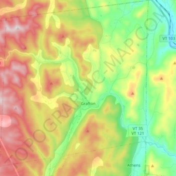
Name: Grafton topographic map, elevation, terrain.

Location: Grafton, Windham County, Vermont, United States (43.12654 -72.68189 43.23530 -72.55548)

Average elevation: 378 m

Minimum elevation: 133 m

Maximum elevation: 690 m

Gear up for your next adventure:

🩹Compact First Aid Kit - Pre-packed essentials for common trail injuries
🥾Trail Hiking Socks - Comfortable socks to prevent blisters and fatigue
🛶Canoe Life Vest - Safety vest for water sports
Camping Essentials - All-in-one gear for a comfortable camping trip
🛏️Camping Sleeping Mat - Comfortable mats for sleeping outdoors

As an Amazon Associate, this site earns from qualifying purchases at no extra cost to you.