Geolocate

Davisville topographic map

Click on the map to display elevation.

About this map

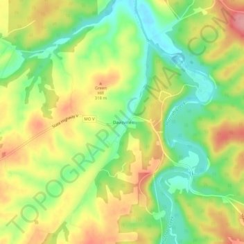
Name: Davisville topographic map, elevation, terrain.

Location: Davisville, Crawford County, Missouri, 65456, United States (37.78782 -91.20514 37.82782 -91.16514)

Average elevation: 287 m

Minimum elevation: 236 m

Maximum elevation: 343 m

Other topographic maps

Click on a map to view its topography, its elevation and its terrain.

St. Cloud

United States > Missouri > Crawford County

Average elevation: 293 m

Bourbon

United States > Missouri > Crawford County

Average elevation: 277 m

Steelville

United States > Missouri > Crawford County

Average elevation: 256 m

Gear up for your next adventure:

🔭Compact Monocular - One-handed bird watching and trail spotting
🧥Waterproof Hiking Jacket - Protect yourself from rain and wind while hiking
🥾Waterproof Hiking Shoes - Durable shoes for wet and rugged trails
🔦LED Headlamp - Hands-free lighting for early morning starts or late finishes
🥾Light Hiking Boots - Lightweight and comfortable boots for day hikes

As an Amazon Associate, this site earns from qualifying purchases at no extra cost to you.