
Make a donation
Gear up for your next adventure:
As an Amazon Associate, this site earns from qualifying purchases at no extra cost to you.
Bellinzona topographic map
Click on the map to display elevation.
Make a donation
Gear up for your next adventure:
As an Amazon Associate, this site earns from qualifying purchases at no extra cost to you.
Bellinzona
Bellinzona is situated in the valley of the river Ticino, at an altitude of 240 metres (790 ft). The town centre lies about 1 kilometre (0.62 mi) east of the river, with the urban area confined to the bottom and lower slopes of the valley. However the municipality's boundaries extend up both sides of the valley, to altitudes of 2,240 metres (7,350 ft) to the west, and 2,195 metres (7,201 ft) to the east.
Make a donation
Gear up for your next adventure:
As an Amazon Associate, this site earns from qualifying purchases at no extra cost to you.
About this map
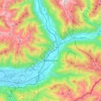
Name: Bellinzona topographic map, elevation, terrain.
Average elevation: 1,083 m
Minimum elevation: 195 m
Maximum elevation: 2,682 m
Make a donation
Gear up for your next adventure:
As an Amazon Associate, this site earns from qualifying purchases at no extra cost to you.
Other topographic maps
Click on a map to view its topography, its elevation and its terrain.