
Make a donation
Gear up for your next adventure:
As an Amazon Associate, this site earns from qualifying purchases at no extra cost to you.
Windisch Bleiberg topographic map
Click on the map to display elevation.
Make a donation
Gear up for your next adventure:
As an Amazon Associate, this site earns from qualifying purchases at no extra cost to you.
About this map
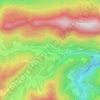
Name: Windisch Bleiberg topographic map, elevation, terrain.
Average elevation: 1,112 m
Minimum elevation: 664 m
Maximum elevation: 1,560 m
Make a donation
Gear up for your next adventure:
As an Amazon Associate, this site earns from qualifying purchases at no extra cost to you.
Other topographic maps
Click on a map to view its topography, its elevation and its terrain.
Tscheppaschlucht
Österreich > Kärnten > Bezirk Klagenfurt-Land > Ferlach > Sapotnica
In der Tscheppaschlucht kommen Pflanzen, die aus der subalpinen und alpinen Höhenstufe herabgeschwemmt wurden (wie die Weiße Silberwurz (Dryas octopetala)) neben wärmeliebenden Arten vor, wie der Gewöhnlichen Felsenbirne (Amelanchier ovalis). Hier vorkommende seltene Arten sind der Frauenschuh (Cypripedium…
Average elevation: 958 m