
Make a donation
Gear up for your next adventure:
As an Amazon Associate, this site earns from qualifying purchases at no extra cost to you.
Pickering topographic map
Click on the map to display elevation.
Make a donation
Gear up for your next adventure:
As an Amazon Associate, this site earns from qualifying purchases at no extra cost to you.
About this map
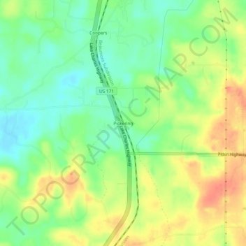
Name: Pickering topographic map, elevation, terrain.
Location: Pickering, Vernon Parish, Louisiana, United States (31.01408 -93.29072 31.05408 -93.25072)
Average elevation: 76 m
Minimum elevation: 52 m
Maximum elevation: 104 m
Make a donation
Gear up for your next adventure:
As an Amazon Associate, this site earns from qualifying purchases at no extra cost to you.
Other topographic maps
Click on a map to view its topography, its elevation and its terrain.
Leesville
United States > Louisiana > Vernon Parish
Leesville is located at 31°8′37″N 93°16′16″W / 31.14361°N 93.27111°W / 31.14361; -93.27111 (31.143553, -93.271196) and has an elevation of 254 feet (77.4 m).
Average elevation: 77 m
Make a donation
Gear up for your next adventure:
As an Amazon Associate, this site earns from qualifying purchases at no extra cost to you.