
Thank you for supporting this site ❤️
Make a donation
Make a donation
Gear up for your next adventure:
As an Amazon Associate, this site earns from qualifying purchases at no extra cost to you.
Aihole topographic map
Click on the map to display elevation.
Thank you for supporting this site ❤️
Make a donation
Make a donation
Gear up for your next adventure:
As an Amazon Associate, this site earns from qualifying purchases at no extra cost to you.
About this map
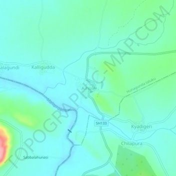
Name: Aihole topographic map, elevation, terrain.
Location: Aihole, Hunagunda taluku, Bagalkote, Karnataka, 587124, India (15.99923 75.86191 16.03923 75.90191)
Average elevation: 531 m
Minimum elevation: 507 m
Maximum elevation: 636 m
Thank you for supporting this site ❤️
Make a donation
Make a donation
Gear up for your next adventure:
As an Amazon Associate, this site earns from qualifying purchases at no extra cost to you.