
Make a donation
Gear up for your next adventure:
As an Amazon Associate, this site earns from qualifying purchases at no extra cost to you.
Palomar Mountain topographic map
Click on the map to display elevation.
Make a donation
Gear up for your next adventure:
As an Amazon Associate, this site earns from qualifying purchases at no extra cost to you.
About this map
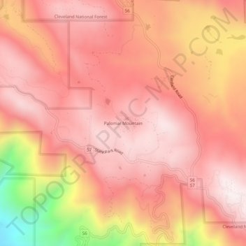
Name: Palomar Mountain topographic map, elevation, terrain.
Average elevation: 1,477 m
Minimum elevation: 868 m
Maximum elevation: 1,717 m
Make a donation
Gear up for your next adventure:
As an Amazon Associate, this site earns from qualifying purchases at no extra cost to you.
Other topographic maps
Click on a map to view its topography, its elevation and its terrain.
La Mesa
United States > California > San Diego County
The climate in the San Diego area, like much of California, often varies significantly over short geographical distances, resulting in micro-climates. In San Diego's case, this is mainly due to the city's topography (the Bay, and the numerous hills, mountains, and canyons). Frequently, particularly during the…
Average elevation: 171 m