
Thank you for supporting this site ❤️
Make a donation
Make a donation
Gear up for your next adventure:
As an Amazon Associate, this site earns from qualifying purchases at no extra cost to you.
Balicha topographic map
Click on the map to display elevation.
Thank you for supporting this site ❤️
Make a donation
Make a donation
Gear up for your next adventure:
As an Amazon Associate, this site earns from qualifying purchases at no extra cost to you.
About this map
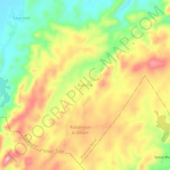
Name: Balicha topographic map, elevation, terrain.
Location: Balicha, Khamnor Tehsil, Rajsamand, Rajasthan, 313322, India (24.86252 73.66839 24.90252 73.70839)
Average elevation: 709 m
Minimum elevation: 615 m
Maximum elevation: 799 m
Thank you for supporting this site ❤️
Make a donation
Make a donation
Gear up for your next adventure:
As an Amazon Associate, this site earns from qualifying purchases at no extra cost to you.