Geolocate

Élancourt topographic map

Click on the map to display elevation.

About this map
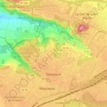
Name: Élancourt topographic map, elevation, terrain.

Location: Élancourt, Rambouillet, Yvelines, Ile-de-France, Metropolitan France, 78990, France (48.75371 1.93644 48.80055 1.98568)

Average elevation: 159 m

Minimum elevation: 82 m

Maximum elevation: 219 m

Other topographic maps

Click on a map to view its topography, its elevation and its terrain.

Rodon

France > Ile-de-France > Yvelines

Average elevation: 167 m

Hautvilliers

France > Ile-de-France > Yvelines > Chevreuse

Average elevation: 127 m

La Corse

France > Ile-de-France > Yvelines > Élancourt

Average elevation: 165 m

Gear up for your next adventure:

🛌Down Sleeping Bag - Superior warmth-to-weight ratio for cold nights
🧴Outdoor Sunscreen - High SPF protection for high-altitude UV exposure
🧣Merino Neck Gaiter - Protects against wind, sun, and cold at high altitudes
🚲Handlebar Phone Mount - View topographic-map.com live while cycling
⛺Camping Groundsheet - Protect your tent from moisture and dirt

As an Amazon Associate, this site earns from qualifying purchases at no extra cost to you.