Geolocate

Malcas topographic map

Click on the map to display elevation.

About this map

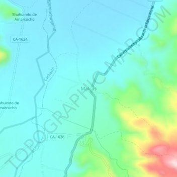
Name: Malcas topographic map, elevation, terrain.

Location: Malcas, Condebamba, Cajabamba, Cajamarca, Perú (-7.53003 -78.16370 -7.49003 -78.12370)

Average elevation: 2,071 m

Minimum elevation: 2,008 m

Maximum elevation: 2,357 m

Gear up for your next adventure:

🧭GPS Tracker - Track your location in remote areas safely
🧥Softshell Jacket - Windproof and breathable jacket for hiking
🧢Hiking Hat - Sun-protective and breathable hats for long treks
🥾Light Hiking Boots - Lightweight and comfortable boots for day hikes
🥾Waterproof Hiking Shoes - Durable shoes for wet and rugged trails

As an Amazon Associate, this site earns from qualifying purchases at no extra cost to you.