Geolocate

San Marcos topographic map

Click on the map to display elevation.

About this map

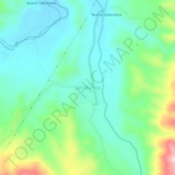
Name: San Marcos topographic map, elevation, terrain.

Location: San Marcos, Soritor, Moyobamba, San Martín, Perú (-6.23901 -77.13811 -6.19901 -77.09811)

Average elevation: 968 m

Minimum elevation: 876 m

Maximum elevation: 1,230 m

Gear up for your next adventure:

🔭Compact Monocular - One-handed bird watching and trail spotting
👟Trail Running Shoes - Agile footwear for fast-paced topographic exploration
🏕️Camping Hammock - Integrated protection for sleeping between trees
🥾Trekking Poles - Adjustable trekking poles to reduce knee stress and improve stability
🧥Waterproof Pants - Keep dry during rainy hiking conditions

As an Amazon Associate, this site earns from qualifying purchases at no extra cost to you.