Geolocate

Tame topographic map

Click on the map to display elevation.

About this map

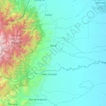
Name: Tame topographic map, elevation, terrain.

Location: Tame, Arauca, RAP Llanos, Colombia (6.06816 -72.36831 6.69774 -71.21928)

Average elevation: 761 m

Minimum elevation: 135 m

Maximum elevation: 5,334 m

Other topographic maps

Click on a map to view its topography, its elevation and its terrain.

Puerto Nariño

Colombia > Arauca > Saravena

Average elevation: 182 m

Gear up for your next adventure:

🍽️Titanium Camping Spork - Ultralight and indestructible eating utensil
🥫Freeze-Dried Meals - Lightweight, high-calorie nutrition for multi-day treks
Camping Essentials - All-in-one gear for a comfortable camping trip
🦟Insect Repellent - Keep mosquitoes and black flies away in wooded areas
🧼Biodegradable Camp Soap - Environmentally friendly cleaning for gear and body

As an Amazon Associate, this site earns from qualifying purchases at no extra cost to you.