
Make a donation
Gear up for your next adventure:
As an Amazon Associate, this site earns from qualifying purchases at no extra cost to you.
Oranienburg topographic map
Click on the map to display elevation.
Make a donation
Gear up for your next adventure:
As an Amazon Associate, this site earns from qualifying purchases at no extra cost to you.
Oranienburg
Die Hochschule der Polizei des Landes Brandenburg führt die Polizeiausbildung für den mittleren, gehobenen und höheren Polizeivollzugsdienst für die Polizei Brandenburg durch. Das erste Studienjahr für den höheren Dienst wird hier gemeinsam für die brandenburgische und die Berliner Polizei durchgeführt. Seit 2006 lässt auch die Polizei des Deutschen Bundestages Polizisten in Oranienburg ausbilden.
Make a donation
Gear up for your next adventure:
As an Amazon Associate, this site earns from qualifying purchases at no extra cost to you.
About this map
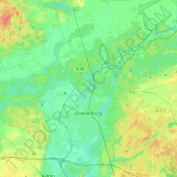
Name: Oranienburg topographic map, elevation, terrain.
Location: Oranienburg, Oberhavel, Brandenburg, 16515, Deutschland (52.70939 13.13096 52.84647 13.43060)
Average elevation: 43 m
Minimum elevation: 29 m
Maximum elevation: 76 m
Make a donation
Gear up for your next adventure:
As an Amazon Associate, this site earns from qualifying purchases at no extra cost to you.
Other topographic maps
Click on a map to view its topography, its elevation and its terrain.
Großmenow
Deutschland > Brandenburg > Oberhavel > Fürstenberg/Havel > Großmenow
Average elevation: 69 m
Make a donation
Gear up for your next adventure:
As an Amazon Associate, this site earns from qualifying purchases at no extra cost to you.
Make a donation
Gear up for your next adventure:
As an Amazon Associate, this site earns from qualifying purchases at no extra cost to you.
Make a donation
Gear up for your next adventure:
As an Amazon Associate, this site earns from qualifying purchases at no extra cost to you.
Nassenheide
Deutschland > Brandenburg > Oberhavel
Die Kirche Löwenberg gehört zum Evangelischen Kirchenkreis Oberes Havelland der evangelischen Landeskirche. Sie ist ein frühgotischer Feldsteinbau mit einem eingezogenen Chor und einem Breitturm (Höhe 19,5 m, Grundfläche 86,4 m²) an der Westseite. Die ältesten Teile der Kirche stammen aus dem 13.…
Average elevation: 39 m
Make a donation
Gear up for your next adventure:
As an Amazon Associate, this site earns from qualifying purchases at no extra cost to you.
Steinhavelmühle
Deutschland > Brandenburg > Oberhavel > Fürstenberg/Havel > Steinförde
Average elevation: 64 m
Großer Stechlinsee
Deutschland > Brandenburg > Oberhavel > Rheinsberg
Der Große Stechlinsee gehört zum Rheinsberger Seengebiet im Naturraum des Neustrelitzer Kleinseenlandes. Er liegt auf dem Gebiet der Gemeinde Stechlin im Landkreis Oberhavel. Das Westufer gehört zum Gebiet der Stadt Rheinsberg im Landkreis Ostprignitz-Ruppin. Am Ostufer liegt das Dorf Neuglobsow. Die…
Average elevation: 72 m
Make a donation
Gear up for your next adventure:
As an Amazon Associate, this site earns from qualifying purchases at no extra cost to you.
Kleiner Wentowsee
Deutschland > Brandenburg > Oberhavel > Gransee > Dannenwalde > Seilershof
Average elevation: 55 m
Emilienfelde
Deutschland > Brandenburg > Oberhavel > Liebenwalde > Liebenwalde
Average elevation: 44 m
Make a donation
Gear up for your next adventure:
As an Amazon Associate, this site earns from qualifying purchases at no extra cost to you.