
Thankamani topographic map
Click on the map to display elevation.
About this map
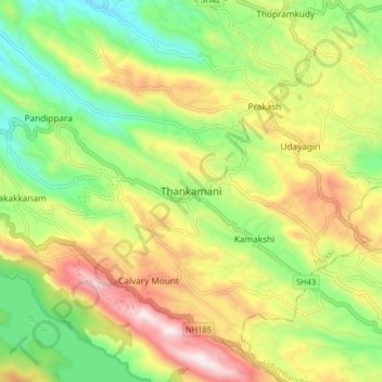
Name: Thankamani topographic map, elevation, terrain.
Location: Thankamani, Idukki, Kerala, 685609, India (9.80137 76.99505 9.88137 77.07505)
Average elevation: 860 m
Minimum elevation: 557 m
Maximum elevation: 1,265 m
Other topographic maps
Click on a map to view its topography, its elevation and its terrain.
Shaji A M Ayyamvellil,Kattapana South Kulam
India > Kerala > Idukki > Kattappana
Average elevation: 909 m
Shaji A M Ayyamvellil,Kattapana South Kulam
India > Kerala > Idukki > Kattappana
Average elevation: 909 m