Geolocate

Chelannur topographic map

Click on the map to display elevation.

About this map

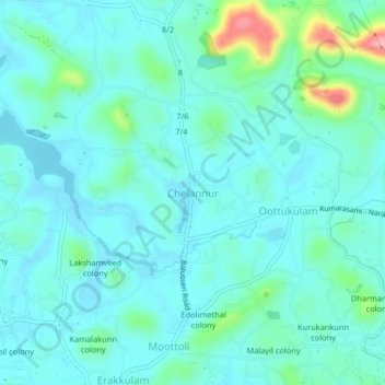
Name: Chelannur topographic map, elevation, terrain.

Location: Chelannur, Kozhikode, Kerala, 673611, India (11.31964 75.79025 11.35964 75.83025)

Average elevation: 27 m

Minimum elevation: 4 m

Maximum elevation: 135 m

Other topographic maps

Click on a map to view its topography, its elevation and its terrain.

Oloppara

India > Kerala > Kozhikode > Chelannur > Chirattatu colony

Average elevation: 20 m

Mananchira

India > Kerala > Kozhikode > Kozhikode

Average elevation: 12 m

Sarovaram Bio Park

India > Kerala > Kozhikode > Erenjippalam

Average elevation: 14 m

Kuthiravattom

India > Kerala > Kozhikode > Kozhikode > Pottammal

Average elevation: 17 m

Gear up for your next adventure:

Camping Coffee Maker - Brew fresh coffee anywhere on the topographic map
👟Leg Gaiters - Keep debris, mud, and snow out of your boots
🧴Sunscreen SPF - Broad-spectrum sunscreen for outdoor activities
Tent Footprint - Protect tent floor and increase durability
🥾Mountain Hiking Boots - High-traction boots for rocky terrain

As an Amazon Associate, this site earns from qualifying purchases at no extra cost to you.