Geolocate

Piura topographic map

Click on the map to display elevation.

About this map

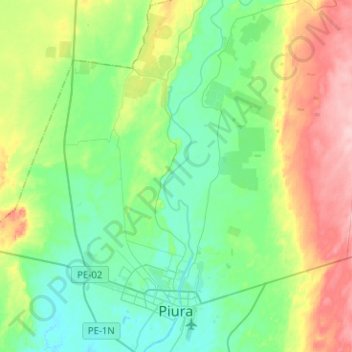
Name: Piura topographic map, elevation, terrain.

Location: Piura, Province of Piura, Piura, Peru (-5.22594 -80.74160 -4.97493 -80.59416)

Average elevation: 68 m

Minimum elevation: 22 m

Maximum elevation: 172 m

Gear up for your next adventure:

🛶Canoe Life Vest - Safety vest for water sports
🥤Collapsible Travel Cup - Saves space and weight in your mess kit
🥾Trail Running Boots - Durable shoes designed for trail running
🧥Waterproof Jacket - Lightweight rain jackets for hiking and outdoor activities
Family Camping Tent - Spacious tent suitable for family camping trips

As an Amazon Associate, this site earns from qualifying purchases at no extra cost to you.