Geolocate

Mulaló topographic map

Click on the map to display elevation.

About this map

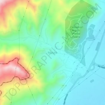
Name: Mulaló topographic map, elevation, terrain.

Location: Mulaló, Yumbo, Sur, Valle del Cauca, RAP Pacífico, Colombia (3.61586 -76.50410 3.65586 -76.46410)

Average elevation: 1,134 m

Minimum elevation: 942 m

Maximum elevation: 1,598 m

Other topographic maps

Click on a map to view its topography, its elevation and its terrain.

Quebrada Arroyohondo

Colombia > Valle del Cauca > Yumbo

Average elevation: 1,001 m

Rio Yumbo

Colombia > Valle del Cauca > Yumbo

Average elevation: 1,085 m

Gear up for your next adventure:

🔨Vehicle Emergency Tool - Safety tool for remote road trips to trailheads
🧭GPS Outdoor Watch - Smart watch for navigation and fitness tracking in nature
🧳Compression Sacks - Maximize space in your backpack by shrinking gear
🥾Approach Shoes - Shoes designed for climbing approaches and rugged trails
🧤Rechargeable Heated Gloves - Extreme warmth for Canadian winter expeditions

As an Amazon Associate, this site earns from qualifying purchases at no extra cost to you.