Geolocate

Cashmere topographic map

Click on the map to display elevation.

About this map

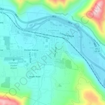
Name: Cashmere topographic map, elevation, terrain.

Location: Cashmere, Chelan County, Washington, United States (47.50746 -120.48868 47.52519 -120.44660)

Average elevation: 298 m

Minimum elevation: 222 m

Maximum elevation: 596 m

Other topographic maps

Click on a map to view its topography, its elevation and its terrain.

Jay Peak

United States > Washington > Chelan County

Average elevation: 1,829 m

Little Bear

United States > Washington > Chelan County

Average elevation: 807 m

Dagger Lake

United States > Washington > Chelan County

Average elevation: 1,845 m

Gear up for your next adventure:

🛌Insulated Sleeping Pad - Critical thermal barrier between you and the cold ground
🛏️Sleeping Bag - Warm and compact sleeping bags for outdoor camping
🧦Thermal Socks - Warm socks for winter hiking or camping
🚲Bike Repair Kit - Essential tools for on-trail mechanical issues
🔭Compact Monocular - One-handed bird watching and trail spotting

As an Amazon Associate, this site earns from qualifying purchases at no extra cost to you.