
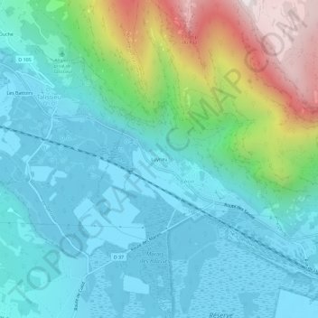
Luyrieu topographic map
Interactive map
Click on the map to display elevation.
About this map
Name: Luyrieu topographic map, elevation, terrain.
Average elevation: 484 m
Minimum elevation: 224 m
Maximum elevation: 1,366 m
Other topographic maps
Click on a map to view its topography, its elevation and its terrain.
Béon
France > Auvergne-Rhône-Alpes > Ain > Culoz-Béon
Béon, Culoz-Béon, Belley, Ain, Auvergne-Rhône-Alpes, France métropolitaine, 01350, France
Average elevation: 533 m
Culoz
France > Auvergne-Rhône-Alpes > Ain > Culoz-Béon
Culoz, Culoz-Béon, Belley, Ain, Auvergne-Rhône-Alpes, France métropolitaine, 01350, France
Average elevation: 459 m
Châtel
France > Auvergne-Rhône-Alpes > Ain > Culoz-Béon > Culoz
Châtel, Culoz, Culoz-Béon, Belley, Ain, Auvergne-Rhône-Alpes, France métropolitaine, 01350, France
Average elevation: 431 m
Landaize
France > Auvergne-Rhône-Alpes > Ain > Culoz-Béon > Culoz
Landaize, Culoz, Culoz-Béon, Belley, Ain, Auvergne-Rhône-Alpes, France métropolitaine, 01350, France
Average elevation: 391 m