
Make a donation
Gear up for your next adventure:
As an Amazon Associate, this site earns from qualifying purchases at no extra cost to you.
Le Guillaume topographic map
Click on the map to display elevation.
Make a donation
Gear up for your next adventure:
As an Amazon Associate, this site earns from qualifying purchases at no extra cost to you.
Le Guillaume
Le Guillaume, aussi appelé Le Guillaume Saint-Paul, est un lit-dit de l'Île de La Réunion, département d'Outre-Mer français situé dans le sud-ouest de l'Océan Indien. Perché à 900 mètres d’altitude, il fait partie de la commune de Saint-Paul et son code postal est le 97423.
Make a donation
Gear up for your next adventure:
As an Amazon Associate, this site earns from qualifying purchases at no extra cost to you.
About this map
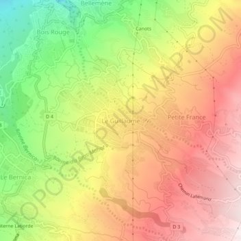
Name: Le Guillaume topographic map, elevation, terrain.
Location: Le Guillaume, Saint-Paul, La Réunion, 97423, France (-21.05831 55.28135 -21.01831 55.32135)
Average elevation: 614 m
Minimum elevation: 171 m
Maximum elevation: 984 m
Make a donation
Gear up for your next adventure:
As an Amazon Associate, this site earns from qualifying purchases at no extra cost to you.
Other topographic maps
Click on a map to view its topography, its elevation and its terrain.
Ravine Saint-Gilles
France > La Réunion > Saint-Paul > Saint-Gilles-les-Hauts > Village de l'Éperon
Average elevation: 310 m
Make a donation
Gear up for your next adventure:
As an Amazon Associate, this site earns from qualifying purchases at no extra cost to you.