
Lathus topographic map
Click on the map to display elevation.
Lathus
Il est situé sur la commune de Lathus-Saint-Remy. C'est une zone classée d’intérêt écologique, faunistique et floristique (ZNIEFF). C’est un petit plan d’eau situé en tête de bassin du ruisseau de la Montagne, un petit affluent de la rive droite de la Gartempe située quelque 3 km à l’ouest du département de la Vienne. Bien que modeste (environ 200 m) l’altitude du site est déjà significative dans le contexte régional et, de fait, la zone est située sur le socle granitique de la bordure occidentale du Massif central et évoque déjà fortement les basses montagnes limousines voisines, dans un paysage de collines couvertes de prairies naturelles et de haies bocagères disséquées profondément par de petites rivières au courant rapide comme la Brame ou la Gartempe. Sur ce substrat de granite, les sols de haut de pente et de têtes de thalwegs, assez profonds, sont installés sur une altérite sablo-argileuse à tendance hydromorphe et les eaux de l’étang sont pauvres en nutriments.
About this map
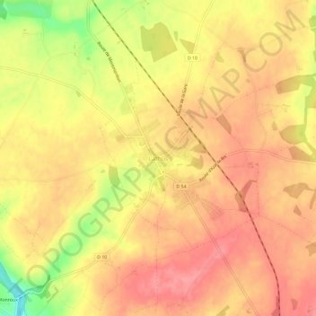
Name: Lathus topographic map, elevation, terrain.
Average elevation: 175 m
Minimum elevation: 117 m
Maximum elevation: 201 m