
Make a donation
Gear up for your next adventure:
As an Amazon Associate, this site earns from qualifying purchases at no extra cost to you.
Dhünn topographic map
Click on the map to display elevation.
Make a donation
Gear up for your next adventure:
As an Amazon Associate, this site earns from qualifying purchases at no extra cost to you.
Dhünn
1815/16 lebten zusammen 1.561 Einwohner in dem Kirchspiel und Spezialhaushaltsgemeinde Dhünn. Laut der Statistik und Topographie des Regierungsbezirks Düsseldorf besaß Dhünn 1832 eine Einwohnerzahl von 1.857, die sich in 23 katholische und 1.834 evangelische Gemeindemitglieder aufteilten. Die Wohnplätze des Kirchspiels umfassten zusammen eine Kirche, zwei öffentliche Gebäude, 255 Wohnhäuser, fünf Fabrikationsstätten und Mühlen und 219 landwirtschaftliche Gebäude.
Make a donation
Gear up for your next adventure:
As an Amazon Associate, this site earns from qualifying purchases at no extra cost to you.
About this map
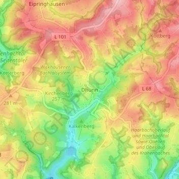
Name: Dhünn topographic map, elevation, terrain.
Average elevation: 259 m
Minimum elevation: 175 m
Maximum elevation: 330 m
Make a donation
Gear up for your next adventure:
As an Amazon Associate, this site earns from qualifying purchases at no extra cost to you.