
Thank you for supporting this site ❤️
Make a donation
Make a donation
Gear up for your next adventure:
As an Amazon Associate, this site earns from qualifying purchases at no extra cost to you.
Bondo topographic map
Click on the map to display elevation.
Thank you for supporting this site ❤️
Make a donation
Make a donation
Gear up for your next adventure:
As an Amazon Associate, this site earns from qualifying purchases at no extra cost to you.
About this map
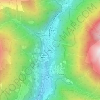
Name: Bondo topographic map, elevation, terrain.
Location: Bondo, Gandellino, Bergamo, Lombardia, 24020, Italia (45.98304 9.92811 46.02304 9.96811)
Average elevation: 1,199 m
Minimum elevation: 663 m
Maximum elevation: 2,088 m
Thank you for supporting this site ❤️
Make a donation
Make a donation
Gear up for your next adventure:
As an Amazon Associate, this site earns from qualifying purchases at no extra cost to you.