Geolocate

Guachaca topographic map

Click on the map to display elevation.

About this map

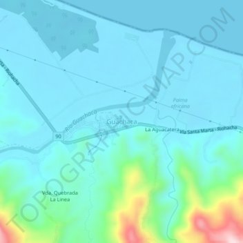
Name: Guachaca topographic map, elevation, terrain.

Location: Guachaca, Santa Marta, Magdalena, RAP Caribe, Colombia (11.23023 -73.84843 11.27023 -73.80843)

Average elevation: 50 m

Minimum elevation: 0 m

Maximum elevation: 351 m

Other topographic maps

Click on a map to view its topography, its elevation and its terrain.

Santa Marta

Colombia > Magdalena > Santa Marta

Average elevation: 214 m

Santa Marta

Colombia > Magdalena > Santa Marta

Average elevation: 214 m

Santa Marta

Colombia > Magdalena > Santa Marta

Average elevation: 214 m

Santa Marta

Colombia > Magdalena > Santa Marta

Average elevation: 214 m

Arrecifes Beach

Colombia > Magdalena > Santa Marta

Average elevation: 31 m

Gear up for your next adventure:

🥾Hiking Leggings - Comfortable leggings for outdoor activities
🔥Camping Stove - Portable stoves to cook outdoors with ease
🕯️Camping Lantern - Illuminates your entire campsite with high-efficiency LEDs
🧭GPS Handheld Device - Reliable GPS navigation for outdoor adventures
📷Outdoor Action Camera - Capture high-elevation views and rugged adventures

As an Amazon Associate, this site earns from qualifying purchases at no extra cost to you.