
Acres topographic map
Interactive map
Click on the map to display elevation.
About this map
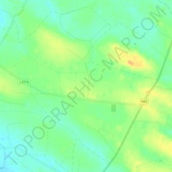
Name: Acres topographic map, elevation, terrain.
Average elevation: 73 m
Minimum elevation: 59 m
Maximum elevation: 91 m
Other topographic maps
Click on a map to view its topography, its elevation and its terrain.
Gort
Gort, Gort ED, Loughrea Municipal District, County Galway, Connacht, Irlande
Average elevation: 25 m
Aille
Aille, Doonbally ED, Tuam Municipal District, County Galway, Connacht, Irlande
Average elevation: 68 m
Loughrea
Loughrea, Loughrea Urban ED, Loughrea Municipal District, County Galway, Connacht, Irlande
Average elevation: 88 m
Clifden (Townland Of)
Clifden (Townland Of), Clifden ED, Conamara Municipal District, County Galway, Connacht, H71 AW08, Irlande
Average elevation: 52 m
Moycullen
Moycullen, Moycullen ED, Conamara Municipal District, County Galway, Connacht, Irlande
Average elevation: 10 m
Illion
Illion, Illion ED, Conamara Municipal District, County Galway, Connacht, Irlande
Average elevation: 184 m
Baie de Galway
Baie de Galway, County Galway, Connacht, Irlande
Average elevation: 35 m
Gortnarup
Gortnarup, Cloonbur ED, Conamara Municipal District, County Galway, Connacht, Irlande
Average elevation: 114 m
Aille
Aille, Bearna, Conamara Municipal District, County Galway, Connacht, Irlande
Average elevation: 51 m
Ballard
Ballard, Cloonbur ED, Conamara Municipal District, County Galway, Connacht, Irlande
Average elevation: 120 m
Killeany
Killeany, Árainn, Conamara Municipal District, County Galway, Connacht, H91 P266, Irlande
Average elevation: 23 m
Bunowen
Bunowen, Cushkillary ED, Conamara Municipal District, County Galway, Connacht, Irlande
Average elevation: 81 m
Clontuskert
Clontuskert, Ballinasloe Municipal District, County Galway, Connacht, Irlande
Average elevation: 60 m
Loughrea
Irlande > County Galway > Loughrea
Loughrea, Loughrea Municipal District, County Galway, Connacht, H62KD91, Irlande
Average elevation: 88 m