
Laniel topographic map
Click on the map to display elevation.
About this map
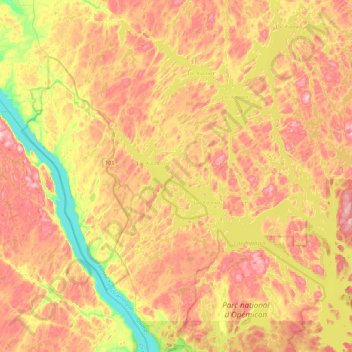
Name: Laniel topographic map, elevation, terrain.
Average elevation: 285 m
Minimum elevation: 170 m
Maximum elevation: 386 m
Témiscamingue trails, hiking, mountain biking, running and outdoor activities
Other topographic maps
Click on a map to view its topography, its elevation and its terrain.
Lac du Bois Franc
Canada > Quebec > Témiscamingue > Les Lacs-du-Témiscamingue
Average elevation: 398 m
Saint-Edouard-De-Fabre
Canada > Quebec > Témiscamingue > Saint-Édouard-de-Fabre
Average elevation: 226 m