
Balimo topographic map
Interactive map
Click on the map to display elevation.
About this map
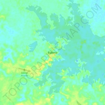
Name: Balimo topographic map, elevation, terrain.
Location: Balimo, Western, Southern Region, Papua New Guinea (-8.07733 142.91898 -7.99733 142.99898)
Average elevation: 6 m
Minimum elevation: -4 m
Maximum elevation: 20 m
Other topographic maps
Click on a map to view its topography, its elevation and its terrain.
Samari
Samari, Western, Southern Region, Papua New Guinea
Average elevation: 1 m
Nomad District
Nomad District, Western, Southern Region, Papua New Guinea
Average elevation: 85 m
Tabubil
Tabubil, Western, Southern Region, Papua New Guinea
Average elevation: 591 m
Biangabip
Papua New Guinea > Western > Biangabip
Biangabip, Western, Southern Region, Papua New Guinea
Average elevation: 466 m
Daru Island
Daru Island, Daru District, Western, Papua Region, Papua New Guinea
Average elevation: 5 m
Daru
Papua New Guinea > Western > Daru
Daru, Western, Papua Region, Papua New Guinea
Average elevation: 1 m