Geolocate

Calitcalit topographic map

Click on the map to display elevation.

About this map

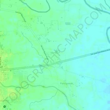
Name: Calitcalit topographic map, elevation, terrain.

Location: Calitcalit, San Juan, Batangas, Calabarzon, Philippines (13.82038 121.39670 13.83729 121.41478)

Average elevation: 12 m

Minimum elevation: 6 m

Maximum elevation: 18 m

Other topographic maps

Click on a map to view its topography, its elevation and its terrain.

Malaking Tubig River

Philippines > Batangas > San Juan

Average elevation: 10 m

Ticalan

Philippines > Batangas > San Juan > Ticalan

Average elevation: 8 m

Hugom

Philippines > Batangas > San Juan > Hugom

Average elevation: 76 m

Gear up for your next adventure:

🧦Outdoor Socks - Durable socks designed for hiking and outdoor sports
🛶Kayak Accessories - Essential gear for safe and fun kayaking adventures
🦯Trekking Poles - Reduced impact on joints for steep topographic climbs
🧊Portable Cooler - Keep food and drinks cold during outdoor adventures
🛏️Sleeping Bag - Warm and compact sleeping bags for outdoor camping

As an Amazon Associate, this site earns from qualifying purchases at no extra cost to you.